
Thanks. I found that image a week or so ago. Am curious if anyone knows why the
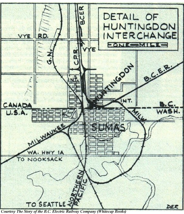
MILW had loop trackage than ran around the south and east sides of Sumas to the
BCER, as shown in the map Roger mentioned. The MILW already had a connection
"downtown" where the three depots were.
I can see the loop track ROW in an aerial photo from 1955 but I can't tell if
the rails were still in place. Perhaps this track was used when the GN was also
in town, to relieve congestion. By 1955 the GN was no longer operating in
Huntingdon, from what I understand.
--Kent
--- In cpsig@xxxxxxxxxxxxxxx, "Roger Traviss" <rogertra@...> wrote:
What I would like the list's help with is understanding the CPR's
operations in 1955 at Huntingdon. I have several good photos of the depot
but few of locomotives and cabeese. I also would like to understand what
trains were running to and from Huntingdon (Scheduled or extra? Train
numbers? Frequency? Etc.) Can anyone help?
This may be of interest.
http://bcer.trams.bc.ca/pics/huntlq.JPG
Roger Traviss
Photos of the late GER: -
http://www.highspeedplus.com/~rogertra/
For more photos not in the above album and kitbashes etc..:-
http://s94.photobucket.com/albums/l99/rogertra/Great_Eastern/