[texbirds] Louisiana Winter Bird Atlas supplemental season, atlasers needed on TX-La border
- From: Richard Gibbons <rgibbo3@xxxxxxxxx>
- To: texbirds@xxxxxxxxxxxxx, Matt Brady <podoces@xxxxxxxxx>
- Date: Mon, 13 Jan 2014 13:48:17 -0600
Dear Texbirders,
I am reposting a message from the Louisiana Birding list with the
justification that the Louisiana Winter Bird Atlas is a very useful
resource for Texas birders. The project has managed to draw observers out
into unbirded areas and the data, entered into eBird, has provided a better
snapshot of winter birdlife in the southern tier of states. There is very
little birding going on along the Texas-Louisiana border and what the
Louisiana birders have managed to do is very impressive. If you have done
much eBird species mapping for East Texas, you may have noticed the stark
disparity of coverage on equally rural sides of the border. Try the last 10
winters for Eastern Towhee in winter as an example:
http://ebird.org/ebird/tx/map/eastow?neg=true&env.minX=-99.26112396712153&env.minY=28.468588946132705&env.maxX=-87.48378021712153&env.maxY=33.27533807233971&zh=true&gp=false&ev=Z&mr=12-2&bmo=12&emo=2&yr=last10
The project was extended one more season in an attempt to fill in some
coverage holes and I thought Texas birders might consider crossing the
border ever so slightly to help turn some quadrangles from gray to green or
green to red in this last season.
Please see message below for the message from Matt Brady, project lead.
Sorry if this topic is out of bounds, but inquiries to get permission were
unanswered.
Richard Gibbons
Houston, TX
---------- Forwarded message ----------
From: Matt Brady <podoces@xxxxxxxxx>
Date: Fri, Jan 10, 2014 at 11:59 AM
Subject: Winter Bird Atlas Starts TODAY!
To: LABIRD <LABIRD-L@xxxxxxxxxxxxxxxx>
Hello all. The final Winter Bird Atlas field season starts today. If you
didn't get enough of Citizen Science during the CBC season, now is your
chance to keep contributing! Here's the webpage outlining the protocol for
the Winter Bird Atlas Project: <
http://www.museum.lsu.edu/~Remsen/WinterBirdAtlas.html >.
Again, this season will be similar to last season, in that plugging gaps in
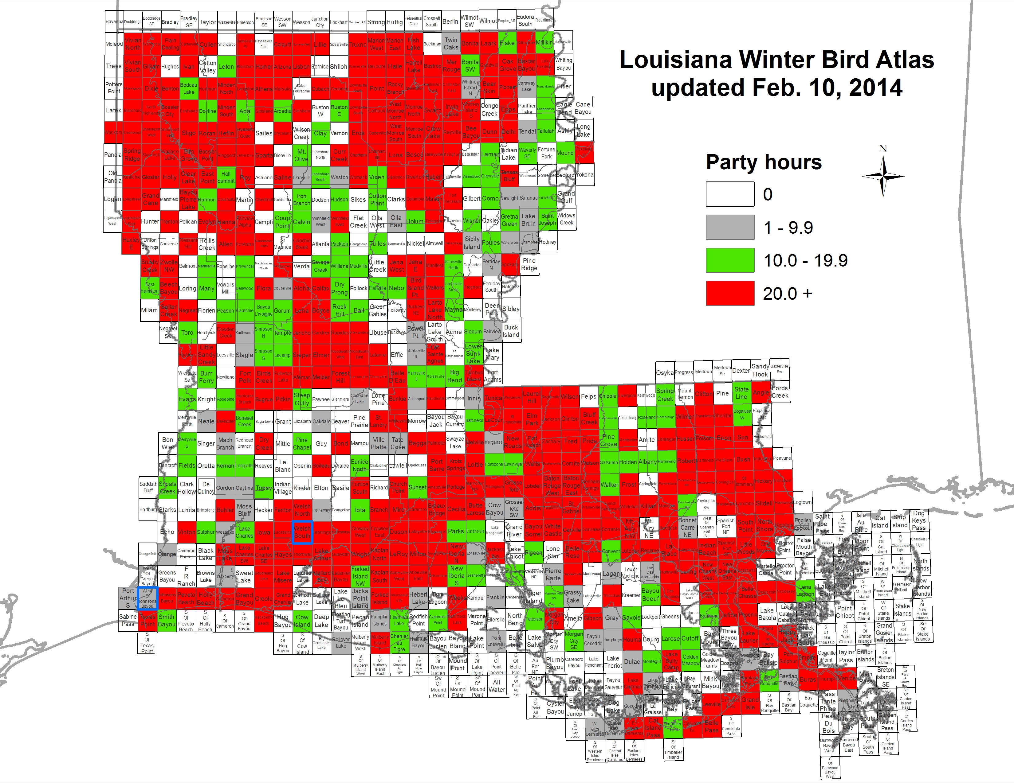
coverage is the goal. Check out this map to see what's already been
covered, as well as what needs to be covered: <
http://www.museum.lsu.edu/~Remsen/LWBA-coverage.jpg >. Covering
under-sampled regions of the state, especially western and coastal
Louisiana (away from Cameron), is what I'd really like to encourage
contributors to consider focusing on this season. Coverage in these areas
is really critical to make the final, published Atlas as comprehensive as
possible. So, any white quad (0 hours) or gray quad (less than 10 hours) is
top priority.
If you can't make it to a remote corner of the state, adding hours to quads
that have had consistent coverage every year for the lifespan of the
project is also important. Inter-year variation in abundance is a really
fascinating area of research, and is something I'd like to explore in the
near future.
I've created a Google document that I'll be using to keep track of quad
coverage progress; the link is here: <
https://docs.google.com/spreadsheet/ccc?key=0ArBhPV7uCbYCdFdac1RmZFhKQ1lpSzFHMGlqc21tWnc&usp=sharing>.
All you have to do is either post your sightings and hours to LABIRD,
or
send the info directly to me. I'll be updating the spreadsheet as data
comes in.
If anyone has any questions about the Atlas project, either in general or
about this year specifically, please don't hesitate to email me.
Thanks, and happy Atlasing!
Matt Brady
Baton Rouge
Edit your Freelists account settings for TEXBIRDS at
//www.freelists.org/list/texbirds
Reposting of traffic from TEXBIRDS is prohibited without seeking permission
from the List Owner
Other related posts:
- » [texbirds] Louisiana Winter Bird Atlas supplemental season, atlasers needed on TX-La border - Richard Gibbons